Berriedale Braes Improvement Report
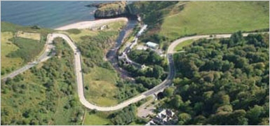
Berriedale Braes lies on the A9 Trunk Road to the north of Helmsdale and to the south of Dunbeath. The location is shown on Figure 1 and Plates 1 and 2 provide aerial photographs of the area.
The road alignment at this location has developed over many years and consequently the geometry is sub-standard when assessed to modern design standards. The terrain is demanding and the road geometry includes a number of tight bends and steep gradients as the road crosses the valley containing the Berriedale and Langwell Waters adjacent to the village of Berriedale.
Gradient
Approximately 1km north of the Berriedale village the A9 drops from an elevation of over 150 mAOD to 20 mAOD as it enters the valley. Gradients of approximately 13% are required to achieve this change in level and on the north side of the valley a hairpin bend, with a radius of approximately 10 metres, has been introduced in order to achieve the change in level within the topographical constraints.
Heavy goods vehicles travelling in either direction take up the whole of the carriageway whilst negotiating the hairpin bend and consequently opposing traffic has to slow down or stop to avoid collisions.
When northbound HGVs give way to southbound traffic they are forced to stop and execute a hill start on a very steep gradient; this is a difficult and potentially dangerous manoeuvre due to the weight re-distribution from front to rear axle of the tractor unit. In May 2010 a coach travelling south ran into the safety barriers after its brakes on the steep downhill just before the hairpin bend…
To view the full report please click here
